 |
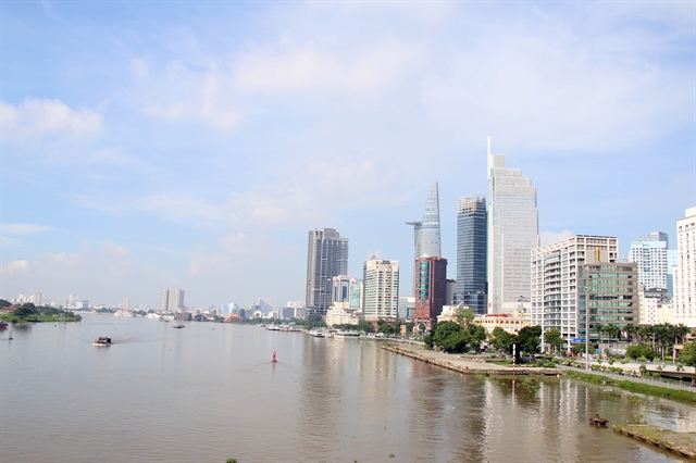
| A view of Bạch Đằng Wharf Park along the Sài Gòn River bank in HCM City’s District 1. — VNA/VNS Photo Tiến Lực |
HCM CITY — The spaces along the Sài Gòn and Đồng Nai rivers are oriented to develop green-ecological areas to foster regional connectivity for mutual development.
This is a key element of the Southeast Regional Planning by 2030, with a vision to 2045, which was approved by the Regional Planning Appraisal Council under the Ministry of Planning and Investment in mid-December.
Several provinces and cities have implemented strategies for exploiting spaces along rivers, yet these efforts are predominantly concentrated within their respective administrative borders, not fully utilising the potential of sustainable interconnectivity.
On December 23, the People’s Committee of Thủ Đức city officially launched a riverside park along the Sài Gòn River, attracting thousands of visitors for sightseeing and photographing.
This showed that parks and riverside paths along the Saigon River are apt for creating green spaces and fulfilling the needs of the city’s residents.
As one of the tributaries of the Đồng Nai River, the Sài Gòn River is 256 km long, including 80 km in HCM City.
The city divides the Sài Gòn River into two zones, including the upper stream extending from Dầu Tiếng Lake to Phù Long Bridge in District 12 and the middle-lower stream from Phù Long Bridge to Mũi Đèn Đỏ in District 7.
The Sài Gòn River holds great potential and advantages for developing the city’s economy and society, and the urban landscape. However, the city has not fully capitalised on this natural advantage in the past.
The areas on both sides of the river have not been installed with utility systems and public service spaces, and the riverside landscape is still underdeveloped.
Some high-potential areas along the river such as the Thủ Thiêm New Urban Area and Thảo Điền Residential Area in Thủ Đức city, and Thanh Đa Peninsula in Bình Thạnh District, have not been fully realized.
According to the city’s Department of Planning and Investment, there are plans for the revitalisation and enhancement of the Sài Gòn River corridor in the city centre from now until 2025. These plans are closely tied to economic and service development initiatives.
From 2025 to 2045, projects will be implemented to invest in green infrastructure integrated with tourism, economic activities, and entertainment services.
The city will also make efforts to refine the legal framework for planning in this riverside area.
The city has actively invested in constructing various services along the Sài Gòn River, such as the upgrade of Bạch Đằng Wharf Park in District 1 covering an area of nearly 1.6 hectares.
It is completing its Sài Gòn River corridor planning and management project, aiming to foster community cohesion, enhance regional connectivity, and promote global outreach, according to its Department of Planning and Architecture.
Nguyễn Tuấn Anh, head of the department’s General Planning Division, said the planning and development of the Sài Gòn corridor have been receiving attention from the city leadership.
By 2030, the project’s vision is to transform the Sài Gòn River banks into a cultural destination in Asia, with an annual growth rate of 8-8.5 per cent.
The central riverside area will feature parks, children’s playgrounds, pedestrian walkways, meditation spots, and communal activity spaces, creating verdant urban retreats for residents.
The city’s rich history and river culture will be highlighted through museums, artistic zones, historical landmarks, street food ventures, and various entertainment activities.
In the Củ Chi District area, the strategic advantage of the river will be harnessed for investments in ferry terminals, cargo transportation, and the advancement of waterway transport.
 |
| The People’s Committee of Thủ Đức city has launched a riverside park along the Sài Gòn River, attracting thousands of visitors for sightseeing and photographing. — VNA/VNS Photo Hoàng Tuyết |
A comprehensive urban and landscape planning strategy has been outlined to transform the Sài Gòn River into a green corridor and a connecting pathway with adjacent urban areas.
It includes exploring urban development or redevelopment strategies that align with heritage sites along the Sài Gòn River area, and developing high-end residential areas along the river to attract capital.
Over the past two decades, the city has allocated numerous hectares of land for urban development along the Sài Gòn River corridor, with 930 hectares already having completed planning.
The core challenge is the need for a specific investment plan and strategy to bring these urban development plans to fruition.
Architect Khương Văn Mười, former chairman of the city Architects Association, said a clear delineation of responsibilities play an important role to actualise the planning and management initiative for the Sai Gon River corridor.
The government is expected to take on specific roles, while the call is made for private sector involvement with transparent benefits, he said.
The investors must strictly adhere to the planning to maintain the landscape on both riverbanks, serving the well-being of residents and contributing to the city’s sustainable development, he added. — VNS
- Reduce Hair Loss with PURA D’OR Gold Label Shampoo
- Castor Oil Has Made a “Huge” Difference With Hair and Brow Growth
- Excessive hair loss in men: Signs of illness that cannot be subjective
- Dịch Vụ SEO Website ở Los Angeles, CA: đưa trang web doanh nghiệp bạn lên top Google
- Nails Salon Sierra Madre
 VnExpress News The News Gateway of Vietnam


